
How does latitude and longitude work. Geographic coordinates of any cities in the world
Rice. 2 Geographic coordinates
The position of various objects on the Earth's surface can be determined using geographic coordinates. To read the coordinates, a system of points and circles is conventionally plotted on the globe (Fig. 2). Let us introduce a number of definitions. The imaginary line around which the earth rotates is called earth's axis. Its points of intersection with the earth's surface are called geographic or true poles: northern PN and southern PS. When a sphere is cut by a plane, a circle is obtained, and a circle is formed on the surface of the sphere. If the cutting plane passes through the center of the ball, then the circle has the largest dimensions and is called big. Circles formed from the section of a ball by planes that do not pass through its center are called small. The circumference of the great circle QQ /, whose plane is perpendicular to the earth's axis, is called equator. It divides the globe into northern and southern hemispheres. Circles of small circles, the planes of which are parallel to the plane of the equator, are called parallels(pp /). The circles of great circles, the planes of which pass through the axis of the Earth, are called geographic or true meridians. The half circle of the PnMPs meridian enclosed between the poles and passing through a given point M is called meridian of the observer (place). The PnGPs meridian passing through the astronomical observatory in Greenwich (England) is called Greenwich(initial or zero) meridian. The Greenwich meridian, together with the opposite meridian PnG / Ps, divides the globe into eastern and western hemispheres.
The geographic coordinate system includes two spherical coordinates: latitude and longitude.
Geographic latitude- this is the angle at the center of the Earth between the equatorial plane and a plumb line drawn through a given point (angle MOL, see Fig. 2). Latitude is measured by a meridian arc from the equator to the parallel of a given point. It is measured north or south of the equator from 0 to 90°. If the point is in the northern hemisphere, its latitude is assigned the name N (northern), if in the southern - S (south). Latitude is denoted by a Greek letter "" (fi). Example: j = 45 0 15¢.2 N; j = 55 0 05¢.1 S
Geographic longitude - is the angle at the center of the Earth between the plane of the Greenwich meridian and the plane of the meridian of the given point (angle GOL, see Fig. 2). Longitude is measured by the smaller of the arcs of the equator between the Greenwich meridian and the point meridian and is measured from the Greenwich meridian to the east or west from 0 to 180 °. If the point is in the eastern hemisphere, then the name E (eastern) is attributed to the longitude, if in the western - W (western). Longitude is denoted by a Greek letter "" (lambda). For example: l \u003d 125 0 16¢.9E; l \u003d 105 0 00¢,1W.
Latitude difference and longitude difference. The geographic coordinates of the vessel change as a result of movement. The changes in latitude and longitude of a ship are called latitude and longitude differences. Latitude difference(RS) two points on earth's surface measured by the meridian arc enclosed between the parallels of these points. Highest value RH can be 180°, which would correspond to the movement of the vessel from one pole to another. If the ship was moving along any one parallel, then RSH is equal to 0°. The calculated RSH is assigned the name “to N” or “to S”, depending on the direction in which the ship was moving. Longitude difference(RD) of two points on the earth's surface is measured by the smaller of the arcs of the equator enclosed between the meridians of these points. Since the smaller of the arcs of the equator is always taken as the difference in longitudes, its value cannot exceed 180 °. If, when adding opposite longitudes, a value greater than 180 ° is obtained, then the addition of up to 360 ° is taken as a taxiway. Such a case may occur when the vessel crosses the 180° meridian. The calculated value of the taxiway is assigned the name of E or W, depending on the direction in which the ship moved. If the northern latitude and eastern longitude are conditionally assigned a plus (+) sign, and the southern latitude and western longitude (-), then the value of RH and RD can be calculated using algebraic formulas:
Rice. 3 Latitude difference and Longitude difference
The sign of the result obtained when calculating by formulas will show the names of RSH and RD. If the addition of up to 360 ° is taken when calculating the RD, then the name of the RD is changed. In order not to be mistaken in the meaning and name of the calculated RSH and RD, one should have a good idea mutual arrangement meridians and parallels on the globe (see Fig. 3,). In practice, it may be necessary to find the coordinates of the point at which the ship arrived, if the coordinates of the point of departure are given, as well as the RS and TW characterizing the position of the point of arrival. Calculations can be made using algebraic formulas.
Globes and maps have a coordinate system. With its help, you can put any object on a globe or map, as well as find it on the earth's surface. What is this system, and how to determine the coordinates of any object on the surface of the Earth with its participation? We will try to talk about this in this article.
Geographic latitude and longitude
Longitude and latitude are geographical concepts that are measured in angular units (degrees). They serve to indicate the position of any point (object) on the earth's surface.
Geographic latitude - the angle between a plumb line at a particular point and the plane of the equator (zero parallel). Latitude in the Southern Hemisphere is called South, while in the Northern Hemisphere it is called North. It can vary from 0 ∗ to 90 ∗ .
Geographic longitude is the angle that is made by the meridian plane at a certain point to the prime meridian plane. If the longitude reading goes east from the initial Greenwich meridian, then it will be eastern longitude, and if it goes west, then it will be western longitude. Longitude values can be from 0 ∗ to 180 ∗ . Most often, on globes and maps, meridians (longitude) are indicated at their intersection with the equator.
How to determine your coordinates
When a person enters emergency he must, above all, be well oriented on the ground. In some cases, it is necessary to have certain skills in determining the geographical coordinates of your location, for example, in order to transfer them to rescuers. There are several ways to do this the handy way. We present the simplest of them.
Determining longitude with a gnomon
If you are traveling, it is best to set your watch to Greenwich Mean Time:
- It is necessary to determine when in the given area there will be noon GMT.
- Stick a stick (gnomon) to determine the shortest solar shadow at noon.
- Detect the minimum shadow cast by the gnomon. This time will be local noon. In addition, this shadow at this time will point due north.
- Calculate the longitude of the place where you are from this time.
Calculations are made based on the following:
- since the Earth makes a complete revolution in 24 hours, therefore, 15 ∗ (degrees) it will pass in 1 hour;
- 4 minutes of time will be equal to 1 geographical degree;
- 1 second of longitude will be equal to 4 seconds of time;
- if noon is before 12 noon GMT, you are in the Eastern Hemisphere;
- if you spotted the shortest shadow after 12 o'clock GMT, then you are in the Western Hemisphere.
An example of the simplest calculation of longitude: the shortest shadow was cast by the gnomon at 11:36, that is, noon came 24 minutes earlier than at Greenwich. Based on the fact that 4 minutes of time are equal to 1 ∗ longitude, we calculate - 24 minutes / 4 minutes = 6 ∗ . This means that you are in the Eastern Hemisphere at 6* longitude.
How to determine geographic latitude
The determination is made using a protractor and a plumb line. To do this, a protractor is made from 2 rectangular strips and fastened in the form of a compass so that the angle between them can be changed.
- The thread with the load is fixed in the central part of the protractor and plays the role of a plumb line.
- With its base, the protractor is aimed at the North Star.
- From the indicators of the angle between the plumb line of the protractor and its base, 90 ∗ is subtracted. The result is the angle between the horizon and polar star. Since this star is only 1 ∗ deviated from the axis of the world pole, the resulting angle will be equal to the latitude of the place where you are currently located.
How to determine geographic coordinates
The simplest way to determine geographic coordinates, which does not require any calculations, is this:
- Google Maps opens.
- Find the exact place there;
- the map is moved with the mouse, zoomed in and out with the mouse wheel
- Find a place by name using the search.
- Click on the desired location with the right mouse button. Select the desired item from the menu that opens. In this case, "What's in there?" Geographic coordinates will appear in the search line at the top of the window. For example: Sochi - 43.596306, 39.7229. They indicate the geographical latitude and longitude of the center of this city. So you can determine the coordinates of your street or house.
By the same coordinates, you can see the place on the map. You can't just change these numbers. If you put longitude first and then latitude, you run the risk of being in a different place. For example, instead of Moscow, you will end up in Turkmenistan.
How to determine the coordinates on the map
To determine the geographic latitude of an object, you need to find the nearest parallel to it from the side of the equator. For example, Moscow is located between the 50th and 60th parallels. The closest parallel from the equator is the 50th. To this figure is added the number of degrees of the meridian arc, which is counted from the 50th parallel to the desired object. This number is equal to 6. Therefore, 50 + 6 = 56. Moscow lies on the 56th parallel.
To determine the geographic longitude of an object, find the meridian where it is located. For example, St. Petersburg lies to the east of Greenwich. Meridian, this one is separated from the zero meridian by 30 ∗ . This means that the city of St. Petersburg is located in the Eastern Hemisphere at a longitude of 30 ∗ .
How to determine the coordinates of the geographic longitude of the desired object, if it is located between two meridians? At the very beginning, the longitude of the meridian that is closer to Greenwich is determined. Then, to this value, it is necessary to add such a number of degrees that is the distance between the object and the meridian closest to Greenwich on the arc of the parallel.
Example, Moscow is located east of the meridian 30 ∗ . Between him and Moscow, the arc of the parallel is 8 ∗ . This means that Moscow has east longitude and it is equal to 38 ∗ (E).
How to determine your coordinates on topographic maps? Geodetic and astronomical coordinates of the same objects differ by an average of 70 m. Parallels and meridians on topographic maps are the inner borders of sheets. Their latitude and longitude are written in the corner of each sheet. Sheets of maps of the Western Hemisphere are marked in the northwest corner of the frame "West of Greenwich". On the maps of the Eastern Hemisphere, respectively, there will be a note "East of Greenwich."
They are necessary in order to find a specific object on a globe or geographical map. Geographic coordinates are geographical latitude, geographical longitude and absoluteheight .
All geographic features on Earth, except for the poles, they have latitude and longitude. All the meridians of the Earth at the pole converge at one point. Therefore, the North and South Poles have only a latitude of 90 degrees.
Maps with parallels and meridians printed on them help sailors find their way among the vast expanses of the ocean. From them you can determine where the ship is located, how long it still has to sail, what lands will meet on the way. Sailors and travelers determine the latitude and longitude of the area with special instruments, working with which requires knowledge of mathematics and astronomy.
Geographic latitude dots is the amount of arc in degrees between the equator and that point. Geographic latitude of any place the globe expressed in degrees, which are measured from the Equator (0°) to the poles (90°).
To determine the geographical latitude of a place on a map or globe, you need to know what parallel it is on. All points on the earth's surface north of the equator have northern latitude, all points in the southern hemisphere have southern latitude.
On the map of the hemispheres in the atlas, the parallels are drawn through 20 °, therefore, not all points on the globe are on the marked parallels.
Determination of latitude
The Suez Canal is located at 30 ° north latitude (abbreviated: n. w.), For example, a parallel of 60 degrees passes through St. Petersburg. This means that the city lies on the 60th degree of northern latitude (NL).
Moscow, lying in the Northern Hemisphere, is located between 40 ° N. sh. and 60° N. sh. It is easy to guess that the latitude of Moscow is approximately 55.5 ° N. sh. (55 degrees 30 minutes north latitude). Both Moscow and St. Petersburg and the Suez Canal are north of the Equator, so their latitude is north, south of the Equator any point will have a south latitude (abbreviated: south lat.). Thus, Kerguelen Island in the Indian Ocean is located at 50 ° S. sh.
A parallel of 30 degrees runs through the center of the Drake Passage in the Southern Hemisphere. The latitude of Lake Victoria in Africa is 0 degrees.
To accurately determine a point on a globe or on a map, you need to know, in addition to the geographic latitude, the geographic longitude of this point.
Geographic longitude points is the magnitude of the arc in degrees from the prime meridian to that point on the earth's surface.
Like latitude, longitude is expressed in degrees, which are measured from the prime meridian. The zero meridian is chosen arbitrarily, and it passes through the Greenwich Observatory, located near the city of London. The Greenwich meridian on the globe and geographical map is shown with a thicker line, and at its intersection with the equator it is signed: 0 ° (degrees). Signed at the equator in degrees and all other meridians. These degrees increase in both directions from the zero, Greenwich, meridian and reach the value of 180 degrees on the other side of the Earth. The 180th meridian is also shown with a thick line. The two halves of the Earth's circumference - the Eastern and Western hemispheres - are separated by 180 degrees.
Determination of longitude
To the east of the Greenwich meridian will be east longitude (abbreviated: east longitude), to the west - west (west longitude). The degrees of longitude on the globe and the map of the hemispheres are indicated on the Equator. Thus, the Suez Canal is located at 32°E. Yes strait of Gibraltar— already at 5° W. d. material from the site
Through city of St. Petersburg passes the 30 degree meridian in the Eastern Hemisphere. So the longitude of this city is 30 degrees east (30° east).
Through Bering Strait which separates Eurasia and North America, passes the 170th meridian of the Western Hemisphere. So, its longitude is 170° West (170° W).
Moscow city It is located in the Eastern Hemisphere between the meridians 30 degrees and 40 degrees. Divide this distance into 10 parts - 10 degrees. The longitude of Moscow will be approximately 37 degrees east longitude. It can be determined more precisely - 37.5 ° E. Degrees are divided into minutes, and there are 60 minutes in one degree. They also say that Moscow is located at 37 degrees 30 minutes east.
Measured from 0° to 90° either side of the equator. The geographical latitude of points lying in the northern hemisphere (northern latitude) is considered to be positive, the latitude of points in the southern hemisphere is negative. It is customary to speak of latitudes close to the poles as high, and about those close to the equator - as about low.
Due to the difference in the shape of the Earth from the ball, the geographical latitude of the points differs somewhat from their geocentric latitude, that is, from the angle between the direction to a given point from the center of the Earth and the plane of the equator.
Longitude
Longitude- the angle λ between the plane of the meridian passing through the given point, and the plane of the initial zero meridian, from which the longitude is counted. Longitudes from 0° to 180° east of the prime meridian are called east, to the west - west. Eastern longitudes are considered to be positive, western - negative.
Height
To fully determine the position of a point in three-dimensional space, a third coordinate is needed - height. The distance to the center of the planet is not used in geography: it is convenient only when describing very deep regions of the planet or, on the contrary, when calculating orbits in space.
Within geographical envelope usually used is "height above sea level", measured from the level of a "smoothed" surface - the geoid. Such system of three coordinates turns out to be orthogonal, which simplifies a number of calculations. Altitude above sea level is also convenient in that it is related to atmospheric pressure.
The distance from the earth's surface (up or down) is often used to describe a location, however not serves coordinate
Geographic coordinate system
The main drawback in the practical application of the HCS in navigation is the large values of the angular velocity of this system at high latitudes, which increase up to infinity at the pole. Therefore, instead of HCS, a semi-free CS in azimuth is used.
Semi-free in azimuth coordinate system
The semi-free in azimuth SC differs from the HSC in only one equation, which has the form:
Accordingly, the system has the same initial position that the HCS and their orientation also coincide with the only difference that its axes and are deviated from the corresponding axes of the HCS by an angle for which the equation is valid
The conversion between the HCS and semi-free in the azimuth of the CS is carried out according to the formula
In reality, all calculations are carried out in this system, and then, to issue output information, the coordinates are transformed into the GCS.
Recording formats for geographic coordinates
The WGS84 system is used to record geographic coordinates.
Coordinates (latitude -90° to +90°, longitude -180° to +180°) can be written:
- in ° degrees as a decimal fraction (modern version)
- in ° degrees and "minutes s decimal
- in ° degrees, " minutes and " seconds with a decimal fraction (historical notation)
The decimal separator is always a dot. Positive signs of coordinates are represented by the (in most cases, omitted) sign "+", or by the letters: "N" - north latitude and "E" - east longitude. Negative signs of coordinates are represented either by a "-" sign or by the letters: "S" - southern latitude and "W" - western longitude. Letters can stand both in front and behind.
There are no uniform rules for recording coordinates.
On the maps search engines by default, the coordinates are shown in degrees with a decimal fraction with "-" signs for negative longitude. On Google maps and Yandex maps, latitude first, then longitude (until October 2012, Yandex maps adopted reverse order: longitude first, then latitude). These coordinates are visible, for example, when laying routes from arbitrary points. The search also recognizes other formats.
In navigators, by default, degrees and minutes are more often shown with a decimal fraction with a letter designation, for example, in Navitel, in iGO. You can enter coordinates in accordance with other formats. The degrees and minutes format is also recommended for maritime communications.
At the same time, the original way of writing with degrees, minutes and seconds is often used. Currently, coordinates can be written in one of many ways or duplicated in two main ways (with degrees and with degrees, minutes and seconds). As an example, the options for recording the coordinates of the sign "Zero kilometer of the roads of the Russian Federation" - 55.755831 , 37.617673 55°45′20.99″ N sh. 37°37′03.62″ E d. / 55.755831 , 37.617673 (G) (O) (I):
- 55.755831°, 37.617673° -- degrees
- N55.755831°, E37.617673° -- degrees (+ additional letters)
- 55°45.35"N, 37°37.06"E -- degrees and minutes (+ additional letters)
- 55°45"20.9916"N, 37°37"3.6228"E -- degrees, minutes and seconds (+ additional letters)
Links
- Geographic coordinates of all cities on Earth (English)
- Geographical coordinates of the settlements of the Earth (1) (eng.)
- Geographical coordinates of the settlements of the Earth (2) (eng.)
- Converting coordinates from degrees to degrees/minutes, to degrees/minutes/seconds and vice versa
- Converting coordinates from degrees to degrees/minutes/seconds and vice versa
see also
Notes
Wikimedia Foundation. 2010 .
See what "Geographic coordinates" are in other dictionaries:
See Coordinates. Mountain Encyclopedia. M.: Soviet Encyclopedia. Edited by E. A. Kozlovsky. 1984 1991 ... Geological Encyclopedia
- (latitude and longitude), determine the position of a point on the earth's surface. Geographical latitude j is the angle between the plumb line at a given point and the plane of the equator, counted from 0 to 90 degrees on both sides of the equator. Geographic longitude l angle ... ... Modern Encyclopedia
Latitude and longitude determine the position of a point on the earth's surface. Geographic latitude? the angle between the plumb line at a given point and the plane of the equator, counted from 0 to 90. in both directions from the equator. Geographic longitude? angle between ... ... Big Encyclopedic Dictionary
Angular values that determine the position of a point on the surface of the Earth: latitude - the angle between the plumb line at a given point and the plane of the earth's equator, is measured from 0 to 90 ° (north latitude north of the equator and south latitude south); longitude ... ... Marine dictionary
Geographic longitude and latitude are used to accurately determine the physical location of any object on the globe. by the most in a simple way finding geographic coordinates is to use a geographic map. This method requires some theoretical knowledge for its implementation. How to determine the longitude and latitude is described in the article.
Geographical coordinates
Coordinates in geography are a system in which each point on the surface of our planet is assigned a set of numbers and symbols that allows you to accurately determine the position of this point. Geographical coordinates are expressed in three numbers - this is latitude, longitude and height above sea level. The first two coordinates, that is, latitude and longitude, are most often used in various geographical tasks. The origin of the report in the geographic coordinate system is at the center of the Earth. Spherical coordinates are used to represent latitude and longitude, which are expressed in degrees.
Before considering the question of how to determine longitude and latitude by geography, you should understand these concepts in more detail.
The concept of latitude

The latitude of a particular point on the surface of the Earth is understood as the angle between the equatorial plane and the line connecting this point with the center of the Earth. Through all points on having the same latitude, you can draw a plane that will be parallel to the plane of the equator.
The plane of the equator is the zero parallel, that is, its latitude is 0 °, and it divides the entire globe into the southern and northern hemispheres. Accordingly, the north pole lies on parallel 90° north latitude and the south pole lies on parallel 90° south latitude. The distance that corresponds to 1° when moving along a particular parallel depends on which parallel it is. With increasing latitude when moving north or south, this distance decreases. Thus is 0°. Knowing that the circumference of the Earth at the latitude of the equator has a length of 40075.017 km, we obtain a length of 1 ° along this parallel equal to 111.319 km.
Latitude indicates how far north or south of the equator a given point lies on the Earth's surface.
The concept of longitude
The longitude of a particular point on the surface of the Earth is understood as the angle between the plane passing through this point and the axis of rotation of the Earth, and the plane of the prime meridian. According to the settlement agreement, the meridian is supposed to be zero, which passes through the Royal Observatory in Greenwich, located in the southeast in England. The Greenwich meridian divides the globe into east and
Thus, each line of longitude passes through the north and south poles. The lengths of all meridians are equal and amount to 40007.161 km. If we compare this figure with the length of the zero parallel, then we can say that the geometric shape of the planet Earth is a ball flattened from the poles.
Longitude shows how far west or east of the zero (Greenwich) meridian lies a specific point on Earth. If latitude has a maximum value of 90° (latitude of the poles), then the maximum value of longitude is 180° west or east of the prime meridian. The 180° meridian is known as the international date line.
One can ask an interesting question, the longitude of which points cannot be determined. Based on the definition of the meridian, we get that all 360 meridians pass through two points on the surface of our planet, these points are the southern and north pole.

Geographic degree
From the above figures it can be seen that 1 ° on the Earth's surface corresponds to a distance of more than 100 km, both along the parallel and along the meridian. For more accurate coordinates of the object, the degree is divided into tenths and hundredths, for example, they talk about 35.79 north latitude. In this form, information is provided by satellite navigation systems such as GPS.
Ordinary geographical and topographic maps represent fractions of a degree in the form of minutes and seconds. So, each degree is divided into 60 minutes (denoted by 60"), and each minute is divided into 60 seconds (denoted by 60""). Here you can draw an analogy with the representation of the measurement of time.
Getting to know the map

To understand how to determine the geographical latitude and longitude on the map, you must first familiarize yourself with it. In particular, you need to figure out how the coordinates of longitude and latitude are represented on it. First, the top of the map shows the northern hemisphere, the bottom shows the southern. The numbers on the left and right of the edge of the map indicate latitude, and the numbers at the top and bottom of the map are longitude coordinates.
Before you determine the coordinates of latitude and longitude, you must remember that they are presented on the map in degrees, minutes and seconds. Do not confuse this system of units with decimal degrees. For example, 15" = 0.25°, 30" = 0.5°, 45"" = 0.75".
Using a geographic map to determine longitude and latitude
Let us explain in detail how to determine longitude and latitude by geography using a map. To do this, you must first purchase a standard geographical map. This map can be a map of a small area, region, country, continent, or the whole world. To understand which card to deal with, you should read its name. At the bottom, under the name, the limits of latitudes and longitudes, which are presented on the map, can be given.
After that, you need to select some point on the map, some object that needs to be marked in some way, for example, with a pencil. How to determine the longitude of an object located at a selected point, and how to determine its latitude? The first step is to find the vertical and horizontal lines that lie closest to the selected point. These lines are the latitude and longitude, the numerical values of which can be viewed at the edges of the map. Assume that the chosen point lies between 10° and 11° north latitude and 67° and 68° west longitude.
Thus, we know how to determine the geographic latitude and longitude of the object selected on the map with the accuracy that the map provides. In this case, the accuracy is 0.5°, both in latitude and longitude.
Determination of the exact value of geographical coordinates
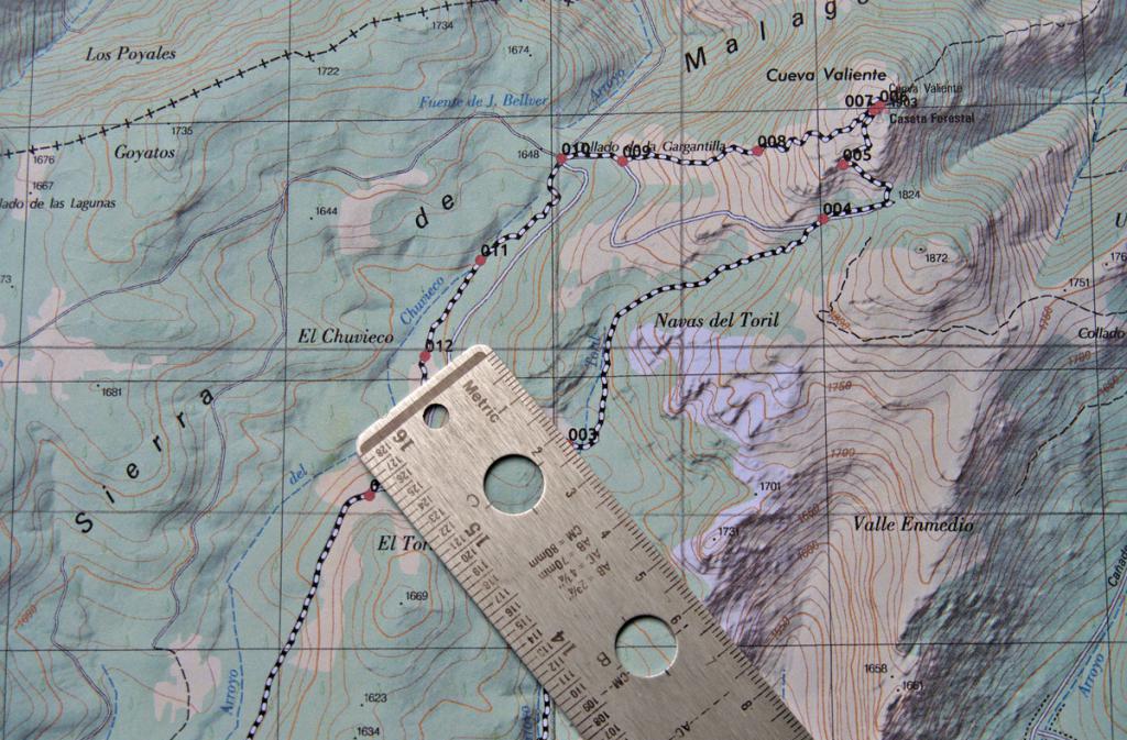
How to determine the longitude and latitude of a point more precisely than 0.5 °? First you need to find out what scale the map with which you are working is. Usually, a scale bar is indicated in one of the corners of the map, showing the correspondence of distances on the map to distances in geographical coordinates and in kilometers on the ground.
After the scale bar is found, it is necessary to take a simple ruler with millimeter divisions and measure the distance on the scale bar. Let in this example, 50 mm corresponds to 1 ° latitude and 40 mm - 1 ° longitude.
Now we position the ruler so that it is parallel to the lines of longitude drawn on the map, and measure the distance from the point in question to one of the nearest parallels, for example, the distance to the 11 ° parallel is 35 mm. We make up a simple proportion and find that this distance corresponds to 0.3 ° from the 10 ° parallel. Thus, the latitude of the point under consideration is +10.3° (the plus sign means north latitude).
Similar actions should be done for longitude. To do this, place the ruler parallel to the lines of latitude and measure the distance to the nearest meridian from the selected point on the map, for example, this distance is 10 mm to the meridian of 67 ° west longitude. According to the rules of proportion, we obtain that the longitude of the object in question is -67.25 ° (the minus sign means longitude west).
Convert received degrees to minutes and seconds

As stated above, 1° = 60" = 3600"". Using this information and the rule of proportion, we find that 10.3° corresponds to 10°18"0"". For the longitude value, we get: 67.25 ° = 67 ° 15 "0"". In this case, the proportion was used once for the longitude and latitude for the conversion. However, in the general case, when fractional minutes are obtained after using the proportion once, it follows use the proportion a second time to get the value of incremental seconds. Note that the accuracy of determining the coordinates to 1 "corresponds to an accuracy on the surface of the globe equal to 30 meters.
Recording received coordinates
After the question of how to determine the longitude of an object and its latitude has been resolved, and the coordinates of the selected point have been determined, they should be written down correctly. The standard notation is to indicate the longitude after the latitude. Both values must be specified with as many decimal places as possible, since the accuracy of the object location depends on this.
Certain coordinates can be represented in two different formats:
- Using only the degree icon, e.g. +10.3°, -67.25°.
- Using minutes and seconds, for example, 10°18"0"" North, 67°15"0"" West.

It should be noted that when representing geographic coordinates in degrees only, the words "North (South) latitude" and "East (West) longitude" are replaced by the appropriate plus or minus sign.
- The displacement is called the vector connecting the start and end points of the trajectory The vector connecting the beginning and end of the path is called
- Trajectory, path length, displacement vector Vector connecting the initial position
- Calculating the area of a polygon from the coordinates of its vertices The area of a triangle from the coordinates of the vertices formula
- Acceptable Value Range (ODZ), theory, examples, solutions