
In years, a scientific expedition at a drifting station. How scientists were rescued from a collapsing ice floe
On this day, May 21, 1937 - 79 years ago, the expedition of I. Papanin, E. Krenkel, P. Shirshov, E. Fedorov landed on the ice of the Arctic Ocean near the North Pole and deployed the first polar station " North Pole-one".
For decades, thousands of desperate travelers and explorers of the North have sought to get to the North Pole, tried at all costs to hoist the flag of their country there, marking the victory of their people over the harsh and powerful forces of nature.
With the advent of aviation, new opportunities arose to reach the North Pole. Such as the flights of R. Amundsen and R. Byrd on airplanes and the flights of the airships "Norway" and "Italy". But for the serious scientific research In the Arctic, these expeditions were short-lived and not very significant. The real breakthrough was the successful completion of the first high-latitude Soviet air expedition and the landing on drifting ice in 1937 of the heroic "four" under the leadership of I. D. Papanin.

So, O.Yu. Schmidt headed the air part of the transfer to the Pole, and I. D. Papanin was responsible for its sea part and wintering at the drifting station "SP-1". The expedition plans included a landing in the North Pole region for a year, during which it was supposed to collect a huge amount of various scientific data on meteorology, geophysics, and hydrobiology. Five planes took off from Moscow on 22 March. The flight ended on May 21, 1937.
At 11:35 a.m., the flagship aircraft under the control of the commander of the Hero's flight detachment Soviet Union M.V. Vodopyanov landed on the ice, flying 20 km beyond the North Pole. And the last of the planes landed only on June 5, the flight and landing conditions were so difficult. On June 6, the flag of the USSR was raised over the North Pole, and the planes set off on their return journey.
Four brave researchers remained on the ice floe with a tent for life and work, two radio stations connected by an antenna, a workshop, a meteorological booth, a theodolite for measuring the height of the sun and warehouses built of ice. The expedition included: P.P. Shirshov - hydrobiologist, glaciologist; E.K. Fedorov - meteorologist-geophysicist; THIS. Krenkel - radio operator and I.D. Papanin is the head of the station. There were months of exhausting work, hard life. But it was a time of mass heroism, high spirituality and impatient striving forward.


Every day of stay at the North Pole brought new discoveries to the researchers, and the first of them was the depth of water under the ice at 4290 meters. Daily at certain deadlines observations, soil samples were taken, drift depths and speed were measured, coordinates were determined, magnetic measurements, hydrological and meteorological observations were made.
Soon the drift of the ice floe, on which the researchers' camp was located, was discovered. Her wanderings began in the region of the North Pole, then the ice floe rushed south at a speed of 20 km per day.
A month after the landing of the Papaninites on the ice floe (as the brave four were dubbed all over the world), when the Kremlin hosted a solemn meeting of the participants in the World's First Air Expedition to the North Pole, a decree was read out awarding O.Yu. Schmidt and I.D. Papanin with the titles of Hero of the Soviet Union, the rest of the drift participants were awarded the Orders of Lenin. The ice floe, on which the Papanin camp was located, after 274 days turned into a fragment no more than 30 meters wide with several cracks.
A decision was made to evacuate the expedition. Behind was a path of 2,500 km across the Arctic Ocean and the Greenland Sea. On February 19, 1938, the polar explorers were removed from the ice floe by the icebreakers Taimyr and Murman. On March 15, the polar explorers were delivered to Leningrad.


Scientific results obtained in a unique drift were presented to the General Meeting of the Academy of Sciences of the USSR on March 6, 1938 and were highly appreciated by specialists. The scientific composition of the expedition was awarded academic degrees. Ivan Dmitrievich Papanin received the title of Doctor of Geographical Sciences.

With the heroic drift of the Papanins, the systematic development of the entire Arctic basin began, which made navigation along the Northern Sea Route regular. Despite all the gigantic obstacles and hardships of fate, the people of Papanin, with their personal courage, wrote one of the brightest pages in the history of the development of the Arctic.
The drift of the first research expedition led by Ivan Papanin began in May 1937. 9 months of work, observations and research of the North Pole station ended when an ice floe collapsed in the Greenland Sea and scientists had to curtail their activities. The entire Soviet Union watched the epic rescue of the four Papanins.
 Ivan Dmitrievich Papanin
The ideologist of this expedition was Otto Yulievich Schmidt. After Stalin's approval, he quickly found people for this project - all of them were not new to the Arctic campaigns. The efficient team consisted of four people: Ivan Papanin, Ernst Krenkel, Evgeny Fedorov and Pyotr Shirshov. The head of the expedition was Ivan Dmitrievich Papanin.
Although he was born on the Black Sea coast in Sevastopol in the family of a sailor, he connected his life with the seas of the Arctic Ocean. Papanin was first sent to the Far North in 1925 to build a radio station in Yakutia. In 1931, he participated in the voyage of the Malygin icebreaker to the Franz Josef Land archipelago, a year later he returned to the archipelago as the head of a field radio station, and then created a scientific observatory and a radio center at Cape Chelyuskin.
 P.P. Shirshov
Hydrobiologist and hydrologist Pyotr Petrovich Shirshov was also not new to Arctic expeditions. He graduated from the Odessa Institute public education, was an employee of the Botanical Garden of the Academy of Sciences, but he was attracted by travel, and in 1932 he was hired on an expedition to the icebreaker A. Sibiryakov", and a year later became a member of the tragic flight on the Chelyuskin.
 E.K. Fedorov
The youngest member of the expedition was Evgeny Konstantinovich Fedorov. He graduated from Leningrad University in 1934 and devoted his life to geophysics and hydrometeorology. Fedorov was familiar with Ivan Papanin even before this expedition "North Pole - 1". He worked as a magnetologist at the polar station in Tikhaya Bay at the FJL, and then at the observatory at Cape Chelyuskin, where Ivan Papanin was his boss. After these winterings, Fedorov was included in the team for drifting on an ice floe.
 THIS. Krenkel
The virtuoso radio operator Ernst Teodorovich Krenkel in 1921 graduated from the courses of radiotelegraph operators. On the final exams he showed such a high speed of working in Morse code that he was immediately sent to the Lyubertsy radio station. Since 1924, Krenkel worked in the Arctic - first at Matochkin Shar, then at several more polar stations of Novaya and Severnaya Zemlya. In addition, he participated in expeditions on the "Georgy Sedov" and "Sibiryakov" and in 1930 managed to set a world record by contacting the American Antarctic station from the Arctic.
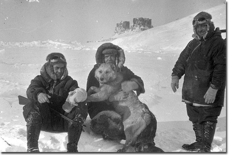
 Dog Cheerful
Another full member of the expedition is the dog Vesely. It was presented by the winterers of the island of Rudolf, from which the planes made a throw to the pole. He brightened up the monotonous life on the ice floe and was the soul of the expedition. The thieving dog never denied himself the pleasure, on occasion, of sneaking into a warehouse with food and stealing something edible. In addition to enlivening the atmosphere, Vesely's main duty was to warn of the approach of polar bears, which he did very well.
There was no doctor on the expedition. His duties were assigned to Shirshov.
 When preparing the expedition, we tried to take into account everything possible - from the operating conditions of the equipment to household trifles. The Papaninites were provided with a solid supply of provisions, a field laboratory, a windmill that generated energy, and a radio station for communication with the earth. However, the main feature of this expedition was that it was prepared on the basis of theoretical ideas about the conditions of stay on the ice floe. But without practice, it was difficult to imagine how the expedition could end and, most importantly, how to remove scientists from the ice floe at all.
 A tent served as a dwelling and camping laboratory for the duration of the drift. The structure was small - 4 by 2.5 meters. It was insulated according to the principle of a down jacket: the frame was covered with three covers: the inner one was made of canvas, the middle one was made of silk stuffed with eiderdown, the outer one was made of thin black tarpaulin soaked in a waterproof composition. Deer skins lay on the canvas floor of the tent as insulation.
The Papaninites recalled that it was very crowded inside and they were afraid to hurt something - laboratory samples were also stored in the tent, raised from the depths of the Arctic Ocean and alcoholized in flasks.
 Papanin is preparing dinner
The requirements for the nutrition of polar explorers were quite strict - each day the diet of each had to consist of food with a calorie content of up to 7000 kcal. At the same time, the food had to be not only nutritious, but also contain a significant amount of vitamins - mainly vitamin C. Concentrated soup mixtures were specially developed to feed the expedition - a kind of current bouillon cubes, only more healthy and rich. One pack of such a mixture was enough to cook a good soup for four members of the expedition. In addition to soups, porridge and compotes could be prepared from such mixtures. Even cutlets were prepared dry for the expedition - in total, about 40 types of instant concentrates were developed - this required only boiling water, and all the food was ready in 2-5 minutes.
In addition to the usual dishes, completely new products appeared in the diet of polar explorers. interesting taste: in particular, crackers, 23 percent meat, and "salty chocolate with an admixture of meat and chicken powder." In addition to concentrates, the Papanin people had butter, cheese, and even sausage in their diet. The expedition members were also provided with vitamin tablets and sweets.
All dishes were made according to the principle that one item fits into another to save space. This subsequently began to be used by manufacturers of dishes not only expeditionary, but also ordinary, household.
 Almost immediately after landing on the ice floe, work began. Petr Shirshov carried out depth measurements, took soil samples, water samples at different depths, determined its temperature, salinity, and oxygen content in it. All samples were immediately processed in the field laboratory. Evgeny Fedorov was responsible for meteorological observations. Atmospheric pressure, temperature, relative humidity, wind direction and speed were measured. All information was transmitted by radio to Rudolf Island. These communication sessions were carried out 4 times a day.
For communication with the earth, the central radio laboratory in Leningrad manufactured two radio stations on special order - a powerful 80 watt and a 20-watt emergency one. The main power source for them was a windmill (besides it there was a hand-operated engine). All this equipment (its total weight was about 0.5 tons) was made under the personal supervision of Krenkel and the guidance of radio engineer N.N. Stromilova.
 Difficulties began in January 1938. The ice floe drifted south and fell into bad weather. A crack appeared on it, and its size rapidly decreased. However, the polar explorers tried to maintain peace of mind and observed the usual daily routine.
“In the tent, our nice old living tent, the kettle was boiling, supper was being prepared. Suddenly, in the midst of pleasant preparations, there was a sharp push and a creaking rustle. It seemed that silk or linen was being torn somewhere nearby, ”Krenkel recalled how the ice cracked.
“Dmitrich (Ivan Papanin) could not sleep. He smoked (the first sign of excitement) and busied himself with household chores. Sometimes he looked longingly at the loudspeaker suspended from the ceiling. When pushed, the loudspeaker swayed slightly and rattled. In the morning Papanin offered to play chess. They played thoughtfully, calmly, with full awareness of the importance of the work being done. And suddenly, through the roar of the wind, an unusual noise broke through again. The ice floe shook convulsively. We still decided not to stop the game,” he wrote about the moment when the ice floe cracked right under the tent.
Krenkel then quite casually transmitted Papanin's message on the radio: “As a result of a six-day storm at 8 o'clock in the morning on February 1, in the area of \u200b\u200bthe station, the field was torn apart by cracks from half a kilometer to five. We are on a fragment of a field 300 meters long and 200 meters wide (the initial size of the ice floe was approximately 2 by 5 kilometers). Cut off two bases, also a technical warehouse with secondary property. Everything of value was saved from the fuel and utility depots. There was a crack under the living tent. We will move to the snow house. Coordinates will inform additionally today; If the connection is interrupted, please do not worry.
The ships "Taimyr" and "Murman" have already moved to the polar explorers, but it was not easy to get to the station due to the difficult ice conditions. The planes also could not take the polar explorers from the ice floe - the platform for their landing on the ice collapsed, and one plane sent from the ship itself got lost, and a rescue expedition was created to search for it. The ships were able to break through to the station only when a polynya formed, they received significant damage in the ice along the way.
February 19 at 13:40 "Murman" and "Taimyr" moored to the ice field 1.5 kilometers from the polar station. They took on board all the members of the expedition and their equipment. The last message of the expedition was as follows: “... At this hour we are leaving the ice floe at the coordinates of 70 degrees 54 minutes north, 19 degrees 48 minutes wind and passing over 2500 km in 274 days of drift. Our radio station was the first to announce the news of the conquest of the North Pole, ensured reliable communication with the Motherland, and this telegram ends its work.” On February 21, the Papaninites switched to the Yermak icebreaker, which delivered them to Leningrad on March 16.
 The scientific results obtained in a unique drift were presented to the General Meeting of the USSR Academy of Sciences on March 6, 1938 and were highly appreciated by specialists. All members of the expedition were awarded academic degrees and titles of Heroes of the Soviet Union. This title was also awarded to pilots - A.D. Alekseev, P.G. Golovin, I.P. Mazuruk and M.I. Shevelev.
Thanks to this first expedition, the following ones became possible - in the 1950s, the North Pole - 2 expedition followed, and soon such winterings became permanent. In 2015, the last expedition "North Pole" took place.
The movement of the vessel occurs simultaneously in two environments - in water and air, which are rarely in a calm state. Air environment exerts its effect on a moving ship primarily by the speed (force) and direction of the wind. Wind speed is measured by anemometers and is expressed in meters per second, and strength is in points from 0 to 12 on a special scale (see Table 49 MT-63).The heading angle of the wind is called the course of the ship relative to the wind. Depending on the value of this angle, the ship's courses relative to the wind received various names (Fig. 47).
If the wind blows to the starboard side, then the ship's course relative to the wind is also called "starboard tack", and when it blows to the port side - "port tack".
When, due to a change in the direction of the wind, its heading angle decreases, the wind is said to be setting or becoming steeper; if it increases, then the wind moves away, or becomes fuller. When the change in angle is caused by a change in the course of the ship, then in the first case it is said that the ship is brought to the wind, or lay down more steeply, and in the second, that it went down, or lay down more completely.

Rice. 48
Under the influence of the wind and the waves and currents it causes, a moving ship deviates from the intended course and changes its speed. Consider the effect of wind on a moving ship in the following example (Fig. 48). Let us assume that the ship is moving along some course IR with a speed along the log vl and it is affected by the observed (apparent) wind Kw with a speed w at an angle q. The resultant wind pressure on the ship, equal to the vector A, is applied to the center of the vessel's sail and makes an angle y with its diametrical plane.
Let us decompose the wind pressure resultant A into two components X and Z. The force X is directed along the center plane and is equal to X = A cozy, it affects the speed of the vessel relative to the water (in this case it reduces the speed) vl.
The force Z is directed perpendicular to the diametrical plane, Z = A.siny and causes lateral displacement - the drift of the vessel from the course line at a speed V etc.
Having geometrically added the speed of the ship along the lag vl AND the drift of blows, we obtain the vector of the actual speed of the ship relative to the water v0, in the direction of which the actual movement of the ship occurs under the action of this wind.
The line of the actual movement of the vessel under the action of the wind is called the track line during the drift of the launcher, and the angle between the nordic part of the true meridian and this line is called the track angle. The angle a between the true course line and the drift track is called the drift angle. When solving problems, the drift angle is assigned a sign: with the wind on the right tack - minus, and on the left tack - plus.
With the same strength of the apparent wind, but at different heading angles, its influence on a moving ship is not the same. At heading wind angles equal to 0 or 180°, the drift angle is equal to zero, and at heading angles K w close to 50-60°, it reaches its maximum value due to the fact that the direction Kw is the resultant of the speed and direction of the true wind and the speed of the wind itself. vessel. At angles K w ~ 50 / 60°, the angle between the direction of the true wind and the center plane of the vessel will be approximately 90°.

Rice. 49
The drift angle increases with a decrease in the ship's speed and with an increase in its sail area (in the case of a decrease in the ship's draft). Practice shows that ships with straight stems have less drift than inclined ones, and that ships with sharp lines have less drift than ships with full formations. The wind, creating excitement, causes the ship to roll, worsens the controllability, and the ship becomes less stable on the course (the ship becomes yawed).
With prolonged action of wind in one direction, a surface current is created, which also causes the ship to drift off the true course line.
Thus, the cumulative effect of the wind and the waves and currents caused by it during navigation must be taken into account by introducing a drift correction equal to the drift angle.
True heading, drifting track and drift angle are in the following algebraic relationship (Fig. 49):
At the same time, it should be remembered that the ship, moving along the track with the drift of launcher a, maintains the direction of its diametrical plane parallel to the IR line and the latter always lies closer to the wind, and launcher a - further from the wind (see Fig. 49).
Drift Angle Determination
Currently, there are no instruments for determining the drift angle that are convenient for use on a ship, and only experience and practice enable the navigator to correctly assess the effect of the wind on the ship and its probable drift by wind waves and currents.In the practice of navigation, the drift angle is determined from direct observations using one of the following methods.

Rice. fifty
When sailing in the visibility of the shores according to coastal landmarks. Following the same course KK1 (Fig. 50), several times (at least three) determine the position of the vessel according to coastal landmarks. Then, by connecting the obtained points A1 A2 and A3, the protractor is used to measure the angle between the nordic part of the true meridian and the line of the actual movement of the ship-track line PP1. The drift angle a is obtained as the difference between PU and IR, i.e. a = PU - IR. This value of the drift angle is taken into account in the future. However, it should be borne in mind that such a determination can be made when there is no constant current in the area.
Direction finding of the wake jet (used as an approximate method). The wake stream is a trace of a moving vessel due to the perturbation of the water mass by the rotation of the propellers. With wind, the direction of the wake stream almost does not shift. Therefore, to obtain the drift angle, it is possible to measure the angle between the directions of the center plane of the vessel and the wake jet. Bearings are taken according to the compass closest to the stern, setting the sighting plane of the direction finder parallel to the wake stream. If the reading is noticed on the azimuth circle of the compass, then
A \u003d KU - 180 °,
And if they remove the OKP, then a \u003d OKP - KK.
The value of the drift angle, determined by all available methods, and the conditions under which it was determined (vessel's heading relative to the wind, ship's speed, wind force, ship's state of loading, draft, etc.), must be recorded in a special notebook in order to it was possible under similar conditions to take into account the drift in advance, i.e., when laying, take into account the correction for the wind.
Dead reckoning of the ship's course when drifting
When maintaining a graphical reckoning taking into account the drift angle, in addition to the true course line, a track line is laid when the PU a drifts along a given or calculated drift angle a and above it, in addition to the compass heading and compass correction, indicate the value of the drift angle with the corresponding sign. The distance traveled by the ship (taking into account the correction or the lag coefficient) is always taken into account along the path of the launcher.The distance traveled along the log (except for the outboard) at drift angles of more than 8 ° is calculated with the introduction of a correction for the drift angle according to the formula
If the distance traveled is determined by the revolutions of the propellers (according to the table of correspondence of the speed to the revolutions of the propellers), then no corrections are introduced.
When maintaining a graphical dead reckoning, taking into account the drift, the position of the vessel at the moment of the traverse of the landmark should be plotted on the map; calculate the moment of arrival of the vessel on the traverse of the landmark; determine the shortest distance to the landmark when following a given course and the moment of opening or hiding the landmark.
To plot the ship's position on the map at the time of the traverse of the landmark, the reverse true bearing is calculated using the following formulas. When observing a landmark: right
left
The IIP is laid from the landmark to the PUa, and point A (the intersection of the IIP with PU a) will be the position of the vessel on the map at the moment of traverse (Fig. 51). In order to determine when the ship will actually come to the traverse of the landmark, it is necessary shortly before that to put the compass direction finder on the pre-calculated GST = KK ± 90 ° (+90 ° - landmark on the left, -90 ° - on the right) and observe. As soon as the direction to the landmark coincides with the sighting plane of the direction finder, this moment will be the moment of traverse.
Such a problem often has to be solved when determining the turning point on a new course.

Rice. 51
In order to pre-calculate the moment of arrival of the vessel on the traverse of the landmark, measure on the map along the path line the distance S from the last observed point B to point A (see Fig. 51), obtained by crossing the IIP line with the PUa line, and dividing it by the ship's speed according to lag, get a time interval corresponding to the duration of the ship's transition from point B to point A.
By adding T to the time T1 (observation at point B), we get the moment T2 of the ship's arrival on the traverse, i.e. T2 \u003d T1 + T. To speed up the calculation of the value of T, use Table. 27-b "Time by distance and speed" (MT-63).
To calculate in advance the indication of the lag at the moment the vessel arrives at the beam (at point A), using the distance S, determine the roll according to Table. 28-a or 28-6 (MT-63) depending on the sign Al or according to the formula roll = S/Cl. Then, to the lag reading, during the determination along the landmark (at point B), the found roll is added and ol2 = ol1 + roll is obtained.